Public transportation in Istanbul – how to get around in Istanbul
Are you wondering how to get around in Istanbul? And if public transportation in Istanbul is good? In this article, I’ll show how to reach all major tourist attractions in Istanbul hassle-free using public transportation. Istanbul’s public transportation system is very good, and one of the most enjoyable methods is traveling by ferry.
All information in this article and more is also included in my YouTube video:
Overview public transportation in Istanbul
Before you can use public transportation in Istanbul, you need to buy an Istanbulkart. This card allows you to use any public transportation method (metro, tram, ferry, funicular, bus).
An Istanbulkart costs around 4 Euros and one ride around 60 Euro cents (price as of August 2024).
You can purchase an Istanbulkart at any metro station, tram station or ferry port. There are also machines at the metro stations in both the Istanbul Airport and Sabiha Gökçen Airport.
I will show very practically how to reach the top 15 touristic sights in Istanbul via public transportation (check the map for an overview of all sights).
- Historical peninsula: Hagia Sophia, Topkapı palace, Blue mosque, Basilica Cistern, Grand Bazaar, Spice Bazaar, Süleymaniye mosque
- Beyoğlu district: Galataport, Taksim square, Istiklal street, Galata Tower,
- Ortaköy
- Arnavutköy, Bebek, Rumeli Hisarı promenades
- Üsküdar promenade
- Kadıköy Moda
- Interactive map
At the very end, there is an interactive map with all the top 15 touristic sights andall the relevant public transportation lines (Metros, trams, Marmaray, ferries).

1) Historical peninsula
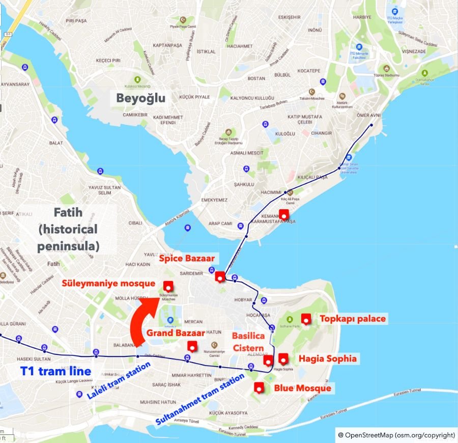
Let’s start with the main touristic sights on the historical peninsula of Fatih. Here you find: Hagia Sophia, Topkapı palace, Blue Mosque, Basilica Cistern, Grand Bazaar, Spice Bazaar, Süleymaniye Mosque
All these sights can be reached via the T1 tram line.
The most important tram stop is Sultanahmet. From there, it’s a short walk to Hagia Sophia, Topkapı Palace, or Blue Mosque. You can also reach Galataport in Karaköy.
During peak hours, this tram line runs every 2 minutes. However it is still often very crowded. The line operates between 6 am and midnight.
For the Süleymaniye Mosque, I recommend getting off at the Laleli tram station and walking from there. The walk is flat and easy. Google Maps does not show this option and suggests instead a tiring walk uphill.
2) Beyoğlu district
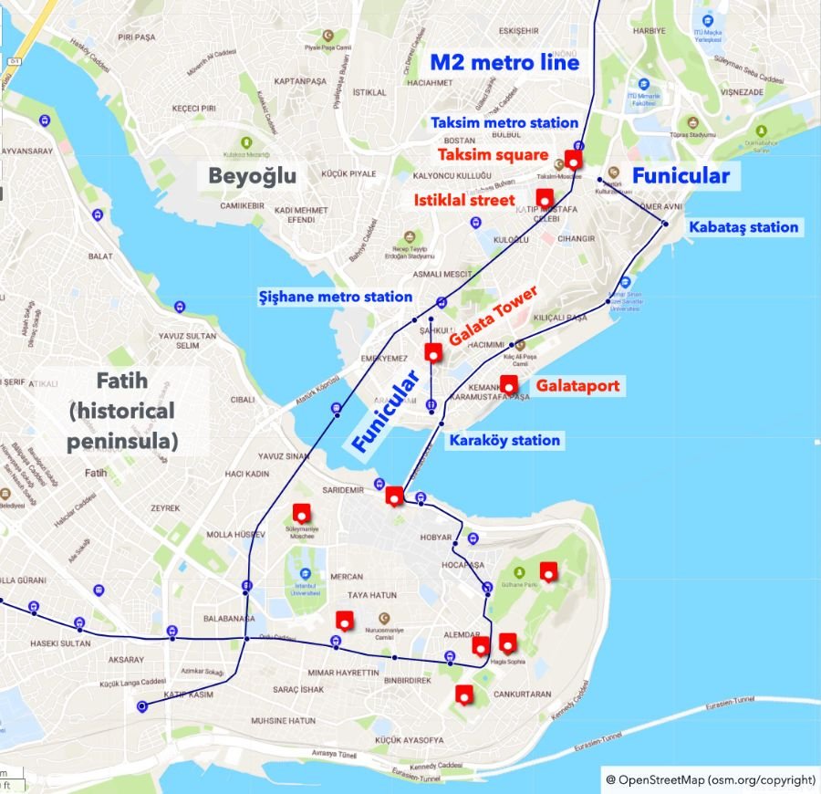
In Beyoğlu, you’ll find Taksim Square, Istiklal Street, the Galata Tower and Galataport.
These sights can be reached via the M2 metro line, which runs between Yenikapı and Hacıosman. The M2 metro line in Istanbul usually operates until midnight, but on Friday and Saturday nights, it runs 24 hours.
Since Beyoğlu is quite steep, there are two funicular lines connecting the Bosphorus level to both Taksim square and the Galata Tower.
There’s a funicular between Kabataş station and Taksim.
Then, there is a second funicular line which is often overlooked by tourists. The station is just next to the Karaköy tram station. This funicular connects to Galata Tower and avoids the steep walk uphill.
Using the T1 tram line, you can reach Galataport.
3) Ortaköy
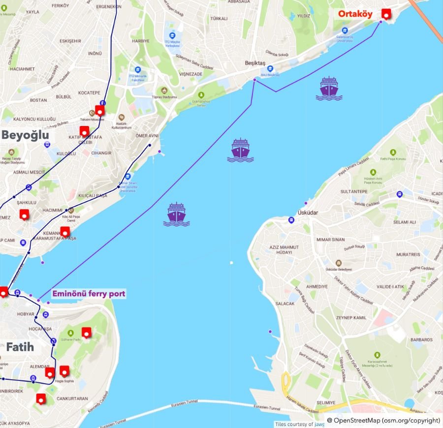
Next, let’s continue with Ortaköy, which is located near the first Bosphorus bridge.
The best way to get to Ortaköy is by ferry. Ferries depart from Eminönü roughly every 30 minutes.
You can also take a bus, but especially on weekends, buses are usually very full. In contrast, a ferry ride is very enjoyable and relaxing.
I recommend downloading the app “Şehir Hatları”. It is available in English and shows the timetable of all ferries operated by the biggest ferry operator. However, note there are also ferries from other operators not shown in the app.
4) Arnavutköy, Bebek, Rumeli Hisarı promenades
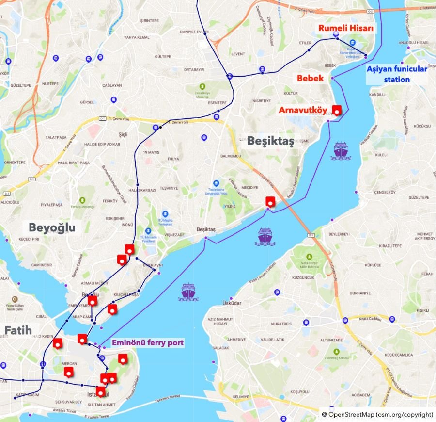
The last sights on the European side are the promenades in Bebek, Arnavutköy, and Rumeli Hisarı.
There are two options to get there:
- You can take a ferry, which I highly recommend. Ferries depart from Eminönü and stop at both Arnavutköy and Bebek. You can choose where to get off. On average, there are ferries every 60 minutes. This ferry ride is almost like a Bosphorus tour.
- Another option is to take the metro. There is a funicular line in Aşiyan connecting the Bosphorus level with the higher level in Hisarüstü. From there, you can access the metro grid and reach Taksim, for example.
5) Üsküdar promenade
Now, let’s move to the Asian side.
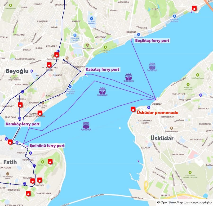
To reach Üsküdar, there are frequent public ferries from Eminönü, Karaköy, Kabataş, and Beşiktaş.
The ride only takes 10-15 minutes, with ferries departing every 20 minutes.
The latest ferry back to Eminönü is around 10 pm.
6) Kadıköy Moda
The second sight on the Asian side is Kadıköy Moda.
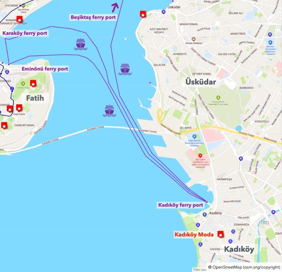
Kadıköy Moda can also be reached by ferry from Eminönü, Karaköy, and Beşiktaş. The ride takes about 20 minutes, with the latest ferry back to Eminönü around 8 pm.
If you want to stay longer in Kadıköy, you can take the Marmaray metro in Istanbul. You can take the metro at Kadıköy metro station and change at Söğütlüçeşme station to the Marmaray. The Marmaray runs below the Bosphorus and connects to Sirkeci and Yenikapı in Fatih.
The Marmaray operates until 11:30 pm, but on Friday and Saturday nights, it runs until 2 am. The Marmaray also stops in Üsküdar, so the same applies to Üsküdar.
Interactive map
This is an interactive map with the top 15 sights and all the relevant public transportation lines (Metros, trams, Marmaray, ferries):
You can explore other articles about Istanbul by clicking on one of the following categories: